Saturday, July 29, 2017

The Eagles' Show, (Not a Rock Concert) -- Sunday, July 23, 2017

On our last day at Cypress Island's Eagle Harbor Herb checks the crab trap one more time and Yes!! as he pulls up the trap, I can see the crab.  I hope it is a keeper.


Well, boo, it isn't.  Just a tad short of the legal size, so the critter goes back into the sea.

With no crabs to clean, we have a consolation prize -- the eagles of Eagle Harbor.   I hear the sweet song and search,  finding several.  The real show is one circling, circling, looking for a fish he can dive for.


On his heels is an ambitious and hungry seagull that will catch any crumbs, or better yet, steal his catch. Apparently the eagle he follows now has some food in his talons, because the gull dive bombs and nips at the majestic bird. Oh, that could be dangerous!


This photo sees the eagle still flying upward with his wings now in the down position.


Now flapping up.


Down again.


Soaring now, he looks for a treetop for landing.


Safe at last.  Did he get to enjoy his food, or did he lose it?


Willie of Willie's Tug,
      and of Walldog, Willie and Jake
      Sunday, July 23, 2017

Monday, July 24, 2017

Hike to the Beach, oh and a Crab! -- Saturday, July 22, 2017

I wake to the faint sound of rain softly tapping the roof of Willie's Tug.  There will be no beautiful sunrise like yesterday, but Dark Sky says it will clear later.   I count on it.


It does begin to clear, and in the meantime I look at the bluff on the north side of Eagle Harbor cove and wonder if any trails lead to the top.  If so, I would label it “Difficult” on the trail map.  I hope no one has ever fallen down that beautiful rock.


On the south side of the bay is the hill with the steep incline that we walked up.  Up, up, wondering if we would ever get to the top.


The rain is gone by lunchtime and we take Jake’s Ferry to shore, look again at the trail map, deciding on a hike to Pelican Beach.  We see evidence of maintenance by the Department of Natural Resources, as these logs look like they have been sawed in two recently.  I suppose the tree fell during the winter storms or winds, as the leaves are still green.


Here it looks like a trail leads off the right, but it is not the main one, so we go straight. Hmmm…it could lead eventually to the peak of the bluff.


Trail is neither steep nor difficult, but has lots of small roots that form steps, making the up and down much easier.  However, I have to constantly look down at the ground to be sure I step safely on or over them.  And look-ee here!  A giant leaf has fallen.  

Yep, not everything is 'bigger in Texas.'


Another reason for constantly looking down is because of the creatures crawling across the trail.  We see many, many banana slugs, so named maybe for their shape, and could it be the spots represent a banana that is getting overripe?


Jackets are really not needed, although it was just a bit chilly dingying over to shore.  When stopping to photograph the disappearing trail at its steepest part, I notice Herb is wearing his jacket tied around his waist, rather than carrying it.


We see a sign ahead and wonder if it is some kind of warning, but it points the way to Duck Lake for folks coming from the direction of Pelican Beach.  On the right is a signpost showing the turn to the right to continue to the beach.


How many ways can I say that I love the forest, nature and getting my Vitamin N?  Over to my right among the growing trees and ferns is what’s left of a very large tree, its tall stump decaying and returning nutrients to the soil. Nature at work.


Are we there yet?   A trail on the right leads down a steep path to the beach, where a small boat of some sort has been pulled up on a beach.  We can't see it really well through the brush, but think it could lead to one end of Pelican Beach.   We continue straight.


Two miles after leaving Eagle Harbor we are at Pelican Beach, which is quite long, and available for anchoring out, as well as tent camping.  There are many, many tents, which causes me to wonder if some organization is having a rendezvous.  They make a lovely sight, and suggest people are having a great time here.

“Murphy, put!  Put!  Murphy, that is not your ball; put it down.”  Murphy is a black lab that thinks he is supposed to fetch any ball that is thrown, and when his owner throws the white bocce ball, off Murphy goes.  Since he cannot have the white one, he goes after the pink one that is already on the beach.

“No, Murphy, that one is not your ball either!”  

Herb and I, as well as the owners, laugh ourselves silly.  The way they get the Lab to leave the balls alone is to throw a stick into the surf.  “Oh, boy! A stick,” says Murphy, as he races into the water and grabs the stick in his mouth.  But not for long, as he realizes it is more like a short log than a stick, and comes back to shore to lie down and rest.

The bocce ball game continues uninterrupted.

From the beach we can see the north side of Cone Islands, whose south side we see from Eagle Harbor.


This looks like a good place to anchor some day, but for now we turn to find the trail entrance and head back.  Herb likes to say that even when you back track, you see the same things, but you see them differently.  Or you see things you did not see the first time. He points, rests his foot on a root b the pile of stones,  and I look intently to finally see it, a cairn that someone has built.


Just so I don’t miss anything in this lovely forest, I slow and look to the right and the left. Wow!  Mother Nature is quite a lady – the roots of a live tree are closed around a decaying log, seen in the upper right hand corner of the photo below.  

Now I ask you – how in the world did this happen?   A time lapse video would be nice, and if the tree could talk, she may tell us that she is holding on tight so the log doesn't leave.

A burned out stump stands behind this one, while in the foreground a growing tree is bent and angles upward.

Sweet!


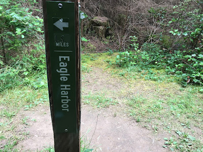
Now we are back to the crossroads and Herb points to the sign that Pelican Beach is half a mile from this point.  On the other side of the post we see one and a half miles to Eagle Harbor.  So a two mile walk one way equals four miles; then we should add in the steps on the beach.


Did I mention the fragrance along the trail?  I wonder what it is and look around.  Could it be the cypress so abundant here?  Yes, I think so, and a close look at the leaves reminds me of what my Mother called arborvitae, which is an evergreen member of the cypress family.


How did I miss this lovely leaf?  I recognize it instantly.  I call it a huckleberry bush, which we found in a marsh near my hometown in Louisiana.  The berries are small, so it takes a lot of picking to get enough for breakfast.  As kids, my sister, Meryl, and I would go out with our small buckets and get as many as we could in an afternoon, bringing them home to wash and refrigerate.  If we got enough, Mama would make jelly.  Oh, the memories.

Soon we are back to Jake’s Ferry and see that the tide has come in.   She is floating, but still hooked around a driftwood root firmly implanted in the beach.  


As we cruise, we find Willie's Tug....


Then we check the crab trap.  Yay!  We get a keeper.  Herb measures him and he passes the test; yes, he is a male!   Legal to keep.  One crab -- only one!   I text the photo to my son-in-law Ed who writes back, “Don’t eat it all at once.”  LOLOL  I tell Ed we hope to get one or five tomorrow. LOLOL

This time Herb puts the crab in his end of the dinghy and constrains him until he gets him in the bucket.


Actually, I think we rescued him, as he is missing his foremost legs (or claws) with which he defends himself.

Willie of Willie's Tug,
   and of Walldog, Willie and Jake
   Saturday, July 22, 2017

Sunday, July 23, 2017

Up the Hill to Reed Lake -- PM (Part II) of Thursday, July 20, 2017

 A catamaran sails really fast (unwise) into the harbor oblivious (unwise) of the crab trap buoys floating about.  Oh, No.  She turns, then goes into reverse to anchor.  (Which is voluntarily restricted to protect Eelgrass). Unbeknownst to him or her driving, the cat is also drifting back to the crab trap buoy.  Just in the nick of time a person on board sees the trap and calls to the pilot to stop.  The catamaran abandons anchoring and hooks a nearby mooring buoy.

Someone’s dinner is saved.  Someone’s prop is not fouled. (No photo posted to protect privacy.)

After the lunch of ‘no crab salad’ today, Herb and I rest a bit, then dinghy back to the beach at 4P for a walk on the trail to the left.  It will take us to Reed Lake and ultimately to Cypress Head at the southern tip of Cypress Island – should we decide to go that far in one walk.  We opt for Reed Lake, a distance of only three quarters of a mile, whereas Cypress Head is two and three quarter miles.  We need to be back to Willie’s Tug by Happy Hour!

As we ‘find Willie’s Tug,’ we take particular note of the white balls in the water.  The one to the left of her is a mooring buoy; the one lower in the photo near the tree limb is also a mooring buoy.  But – the tiny one to the right is a crab trap buoy.  If you watch your surroundings, you can see them.  We are glad all was good.


The Department of Natural Resources Interpretive Panel shows the map of the trail to Reed Lake and tells us it is a natural wetland, but was altered by the earth dam built at the outflow.  It was planned to be a water source for a proposed development.  

Since 1987 the lake has been owned and managed by the Department as part of Cypress Island Natural Resources Conservation Area, one of the first such areas in the state of Washington.

The intent is to conserve its unique ecological values, but the process of change continues.

Continuing on the walk, we begin an uphill climb. 

And we continue to climb uphill.

It is not only up hill, it is a very steep uphill climb!   Steep.  Who knew?  I walk progressively slower and slower and rest a lot.  I will not turn around.  I persevere.  But I don’t take many photos, wisely conserving my energy.  So Herb, bless his heart, sends me his photos for posting in my blog.


We arrive at Reed Lake at 5P and it has been worth the trek to find such a lovely scene.  We both take photos.  First the map of the Reed Lake area, then a zoomed shot of the lake, which is abound with lily pads, seemingly undisturbed.


I suppose burning all those calories is what causes me to take off my jacket and sip from my water bottle.


The lake sits in a basin carved out by the Vashon Glacier, part of a large continental glacier that covered the area 11,000 – 15,000 years ago.  Up to 5,000 feet of ice covered Cypress Island.  When released from the ice 11,000 years ago, Reed Lake was lifeless.  Erosion from streams and rainfall carried nutrients to the sterile lake, and new life colonized the waters.  Bacteria, algae, and protozoa, blown in from surrounding lad, fed on materials deposited in the lake.  Seeds and spores, perhaps dropped from the feathers of visiting waterfowl, allowed plants to take hold.  Changes leading to today’s Reed Lake had begun.

I walk much faster going down the steep hill, than I did going up, so I can stop and take some photos.   In most places the path is wide enough for a Jeep to easily travel, but narrows to a more interesting trail now and then.  I take the time to enjoy the scenery off the path, and especially these rocks in a stream runoff.


It is a great walk today, and I would do it again another day, but might consider starting in the morning and bringing a picnic lunch.

I especially like the quote printed on the Interpretive Panel:

“I only went out for a walk, and finally concluded to stay out till sundown, for going out, I found, was really going in.” – John Muir

Willie of Willie's Tug,

   and of Walldog, Willie and Jake
   Thursday, July 20, 2017